

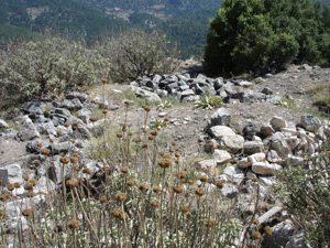
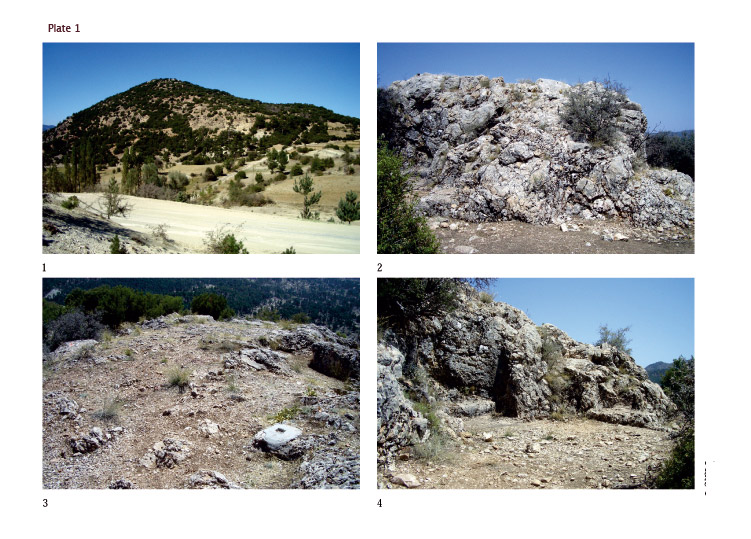
The acropolis occupies the highest peak of the Dikmen Tepesi. Below this peak, remains of the settlement extend east–west along several terraces of differing elevations (pl. 1, 1). The acropolis itself is divided into two areas. In the northwest, above the precipitous northern slope of the Dikmen Tepesi, lies a natural rock massif approximately 15 m in length, 10 m wide, and 3–4 m in height (pl. 1, 2). This massif was formerly taken up by a towerlike building, now attested only by rock-cut beddings for the walls (pl. 1, 3). No interior partition can be ascertained. This building may have served as a kind of hilltop fort, and could have been entered from the south along a narrow path of shallow, rock-cut steps, still extant. The second area is represented by a natural plateau approximately 60 m long and 30 m wide (pl. 2, 1), southeast of the rock massif supporting the ''fort''. The plateau is bordered especially in the south and southeast by steep slopes, falling to a maximum of approximately 10 m. This large plateau preserves an open area at its north, extending from the “fort” to remains of a line of buildings at its southeast, largely destroyed or buried. One of these buildings has several rooms, but its plan can be only barely discerned. A damaged round marble basin is present in one of these poorly preserved rooms.
Cut into the scarp at the southwest of the ''fort'' is a semicircular structure containing a square niche and a small benchlike platform (pl. 1, 4). Rock-cut thresholds for the structure can be made out to the south and northwest. The western end of this roomlike complex would have been defined by a wall, no longer preserved, that continued the line of the acropolis wall, and the complex can be tentatively identified as a nearly round gate chamber. Outside the northwest threshold are traces of an ancient switchback path that ran above the large rock-cut tomb to be discussed next and probably into the valley west of Boubon.
Below the ''fort'' and to the northeast is a small natural terrace on which there probably stood an elongated rectangular building. A small gate, no longer preserved, at the northwest end of this terrace permitted entrance to the settlement, and a precipitous narrow switchback path leading northward from the position of the gate provides access to the valley toward Ibecik.
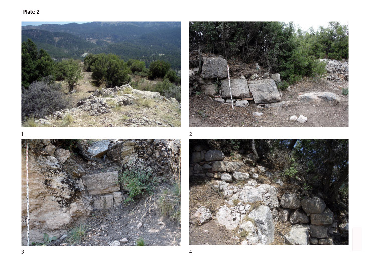
The acropolis was surrounded by a wall that ran along the edge of the steep slopes. Only a few sections of this wall are preserved, primarily in its lowest courses, while others can be conjectured on the evidence of beddings cut into the natural rock. The preserved sections of this wall consist primarily of spolia set into place with mortar and a few fragments of red brick (pl. 2, 2). This masonry technique points to a date of construction in the Byzantine period, but a few stretches of the wall contain remains of masonry that can be provisionally dated to earlier periods (pl. 2, 3). Along with the evidence gained from the rock-cut beddings, these earliest remains indicate that the Byzantine fortification lies almost precisely along the lines of an ancient wall. The ancient fortification possibly included at least two towers, which were discontinued in the wall of the Byzantine period. Apart from the two gates at the north, access to the acropolis was provided also at the south by a series of small steps cut into the nearly vertical rock in a manner similar to those at the ''fort''. Extensive destruction in this area leaves the design of the southern gate, and also of the southern front of the acropolis, unclear.
During the Byzantine period the area below and south of the acropolis was protected by an additional wall that runs nearly parallel to the vertical rocky slope of the acropolis hill. This wall was also built from spolia set in mortar and includes some column drums. A rectangular tower was fixed on its southwest end, and a second one was set at approximately the midpoint of the southeast wall (pl. 2, 4). Both towers possibly protected gates that have since been entirely destroyed. Poor conditions of preservation at the east have left the line of the wall in that area unclear.
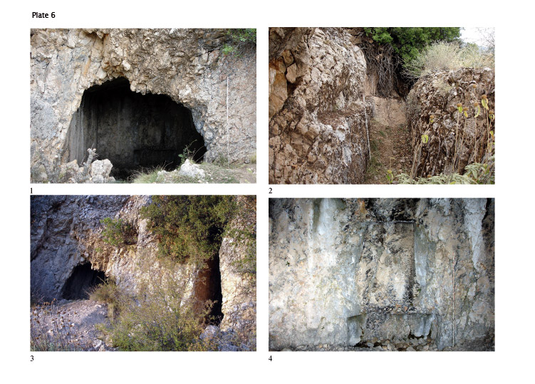
A rock-cut tomb beneath the acropolis
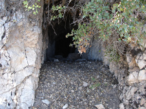
On the western slope of the Dikmen Tepesi and below the acropolis is a large tomb cut into a roughly vertical escarpment (pl. 6, 1). The entrance to the tomb has been nearly entirely eroded due to the fragility of the rock. Originally the entrance was probably a wide rectangular niche-like opening, and it is possible that the façade was further elaborated. Cut into the rock to the right and left of the facade is a corridor, approximately 1.0 m in width, which extends around the tomb (pl. 6, 2–3).
The tomb chamber, measuring approximately 5.0 x 5.0 m, has a gabled roof. Cut into the roughly smoothed back wall (pl. 6, 4) are two niche-like openings, one above the other. The lower niche, a rectangle 2.03 m in length, 0.85 m high, and approximately 1.0 m deep, is of suitable shape for containing a body. The second niche has its highest dimension on its vertical axis, measuring 1.70 m in height, 0.98 m wide, and 0.40 m deep. Convincing parallels for niches of this shape are rare. While niches for the placement of burial gifts occasionally appear in rock-cut tombs, the upper niche at Boubon is unlike them in form and seems too shallow for this purpose. Its function is hence unclear; possibly it is a kind of false door.
Uncertainty about the function of the upper niche may recommend interpretation of the structure as something other than a tomb, and its identification as a rock-cut sanctuary cannot be entirely ruled out. A few such grotto-like rock-cut sanctuaries have been previously identified and published. There is, however, no clear evidence for ritual function associated with the structure at Boubon, and its identification as a tomb--in particular on the evidence of the suitability of the lower niche for receipt of a body--is at present the more convincing interpretation.
The position of the tomb, immediately below the acropolis and immediately below the ''fort'', is remarkably prominent. Its front faces toward the southwest and, prior to the covering of the area by mounting earth, the tomb would have been easily visible from the valley. It was, in addition, readily accessible from the northwest gate of the acropolis. Whether the tomb was situated extra or intra muros, which cannot at present be determined, its prominence suggests its association with a member of the local elite. Although it is possible that the tomb was erected for the use of a family, no evidence for multiple burials exists at the site, and the single funeral niche speaks against the suggestion.
There are few parallels for free-standing rock-cut tombs with a corridor extending around them. A prominent, more elaborate example is the so-called Doric Tomb at Antiphellos (Kaş; central Lycia), whose cube-shaped chamber and surrounding corridor were carved entirely from the natural rock. A similar example is found at Myra, in central Lycia, and others of the type are found in Caria.
In light of the widespread incidence of 5th- and 4th-century rock-cut tombs throughout Caria and Lycia, the suggestion of a Classical date for the tomb at Boubon is probably reasonable. Moreover, if the “fort” can be assigned a date prior to the Hellenistic period, and if its presence marks Boubon as the seat of a local dynast, construction of the tomb is possibly to be connected with that same dynast and date. On the other hand, the tyrant Moagetes, who is mentioned in the 2nd century B.C., might also be a candidate for association with the tomb since according to Posidonius the family originated in Boubon (Diodorus 33.5). Further analysis of other rock-cut tombs in the vicinity of Boubon, currently under study by M. Seyer, should provide more secure grounds for determining the date and other particulars of the tomb.