

The fortified settlement on Kale Tepe east of Boubon (plan)
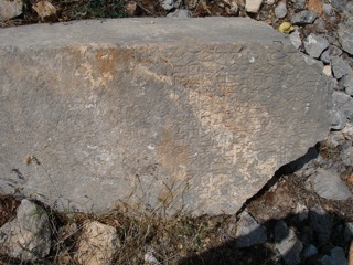
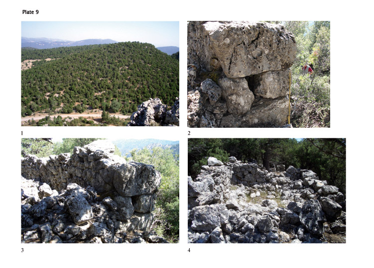
Kale Tepe is an east–west oriented mountain that lies approximately 3 km east of Boubon, presenting a conical shape when viewed from the west. Here, above the remains of a small village or hamlet apparently built during the Roman Imperial period, is located a fortified site (pl. 9, 1).
Within the village, and close to the present-day road--whose course perhaps corresponds to that of the ancient road to Balbura--are traces of a building that appears to have had at least three rooms. Two rectangular statue bases of Imperial date bearing dedications of the agoranomoi (market inspectors) of Boubon addressed to the god Ares are known from this site. One is still preserved, lying in or in front of the building. Of the other inscribed base only small fragments were found, which we have transferred to the museum in Burdur. On the evidence of these bases, the building is perhaps to be identified as a rural sanctuary for the god Ares. Other buildings of possibly ancient date in the village are too destroyed for reconstruction.
The text of the dedications has suggested to scholars the existence of a fort in the area. In his edition of the preserved inscription, F. Schindler proposed that the remains of the village were possibly to be identified as a military site (Schindler 1972, pp. 25–26). Yet it seems that Schindler did not visit the fortified hilltop. G. E. Bean might have seen the fortified site on the hill that he calls Asar Tepesi (Bean 1986, p. 170). The fortifications were perhaps recognized also by T. A. B. Spratt and E. Forbes, who make reference to a fort.
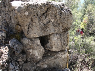
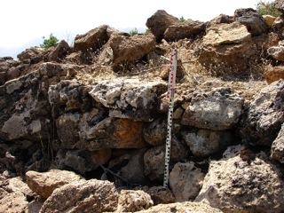
Our own study of this relatively well-preserved site indicates that its function was not exclusively military. The densely built-up interior of the site suggests, instead, that it is a small fortified settlement. The site extends southwest–northeast over the entire hilltop, narrowing at the northeast and ending in a rocky spur. The masonry of the partly preserved fortification wall, with a height of 2.50 m and a thickness of approximately 1.0 m, is mostly rough polygonal, in part a rough ashlar (pl. 9, 2). The size of the stones varies substantially. Three well-preserved gates are found at the north, west, and south. Some very large headers can be seen in those parts of the fortification wall (pl. 9, 3), but in no other context at the site.
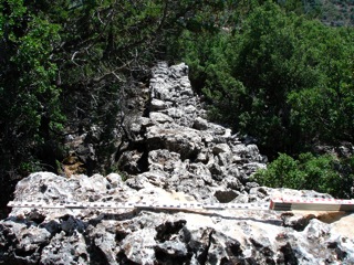
Houses and room complexes nearly fill the interior of the fortified site. Many of the approximately 40 buildings abut the surrounding wall. Narrow streets extending from the three gates meet at right angles near the centre of the settlement, and smaller streets branch off of these. Houses and larger building complexes are situated along the two main streets. The buildings are constructed in the same technique as the fortification wall, but with generally smaller stones (pl. 9, 4. 10, 1).
There are no indications of building phases, repair, renewals, or extensions, and the entire settlement seems to have been built within a short period of time. The period of habitation was presumably also brief. The site shows evidence of strict planning. No public or sacred buildings and precincts, and no cisterns or installations for water supply, are apparent.
Supposing that the lower settlement, in which the dedications to Ares of Imperial date were found, was the Imperial successor of the hilltop site, it would provide a terminus ante quem for the latter. A more precise date for the construction and use of the fortified settlement is dependent on the appearance of the masonry, as pottery sherds and roof tiles, presumably buried in the accumulated earth, are not currently visible. Some characteristic features of the masonry, such as the almost complete absence of headers and the use of the “Reißverschluß” as a technical solution for corners (pl. 10, 2), speak for a pre-Hellenistic date (Cf. Marksteiner 2002, p. 39 and nn. 79–80). However, the clearly visible planning of the settlement casts doubt on such an early dating, and foundation of the settlement in the course of the 4th century BCE seems a reasonable suggestion.
Other fortified sites in the surroundings of Boubon
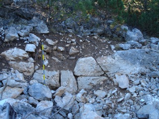
We were able to examine briefly and to take measurements of four smaller fortified sites that have been found in the vicinity of Boubon, at each of which the absence of surface finds presents chronological difficulties. The first is situated approximately 5.5 km east of Boubon and southwest of the Turkish village of Altınyayla. It appears to be a fortified settlement, similar in plan to that on the Kale Tepe but substantially smaller. Set on a hilltop, and oriented generally east–west, the site measures approximately 80 x 30 m. The interior is occupied by a dozen or so rooms, most of which abut the surrounding fortification wall. The 1.20 m extant stretch of the wall, preserved in parts up to a height of 2.0 m, is built of roughly hewn stones that, in contrast to the wall on the Kale Tepe, are set largely in mortar (pl. 10, 3). On this evidence, the date of the construction is presumably no earlier than the Roman Imperial period. A poorly preserved stretch of wall constructed of large trapezoidal blocks in the western area of the site appears, however, to be of substantially earlier date (pl. 10, 4). Set close to a rocky massif, this wall presents beddings similar to those seen at the “fort” on the acropolis of Boubon, and may be the remains of an older, possibly castle-like building, datable by the technique of its masonry to the Classical period.
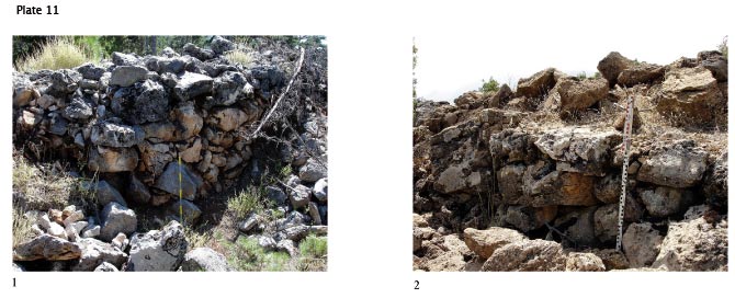
A second fortified site lies close to the Turkish village of Divre southwest of Boubon. Situated on a hill, and measuring approximately 25 x 20 m, the site preserves an outer wall measuring 1.80 m in thickness (pl. 11, 1) and a rectangular building complex within. No gate could be located, but the entrance to the complex was probably at the northwest. A narrow corridor within the site is flanked by two rooms at left and two at right. Outside the outer wall are preserved single, nearly destroyed walls that probably belong to adjoining buildings. The remains suggest the identification of the site as a fortified farmstead, probably to be dated prior to the Hellenistic period on the evidence of the masonry.
Two additional fortified sites were examined only briefly during this past year’s campaign. The first of these, located on a hilltop southwest of Boubon (Küçük Kaletepe/Elmalıyurt), has a nearly circular enclosure wall constructed of roughly hewn stones and measuring approximately 30 m in diameter and 1.60 m in thickness (pl. 11, 2). No traces of interior structures were found. Whether the site is a fortified farmstead or a military complex, and also the question of its date, remain open.
The last of the fortified sites to be explored also lies southwest of Boubon. Here, a poorly preserved wall constructed of nearly unworked stones encloses a square building whose foundations can only barely be made out. Interpretation and date of the site are unsure.
∧ top