

Agora
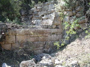
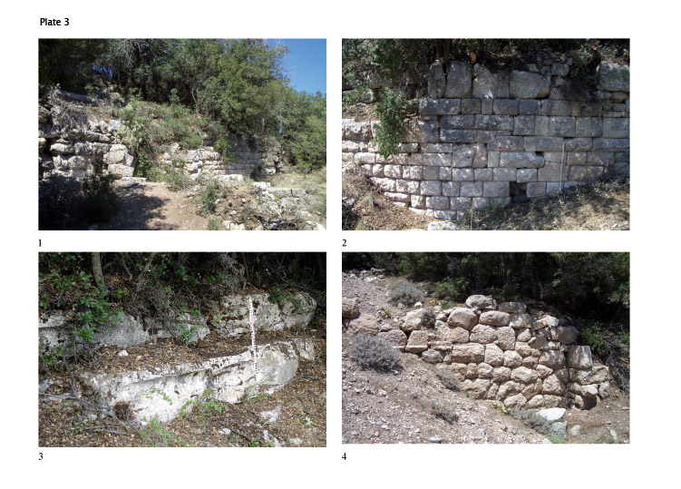
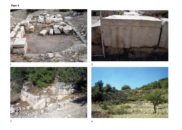
The agora, roughly 150 x 60 m in area, is situated on a wide terrace approximately halfway up the height of the Dikmen Tepe. The theatre and the Sebasteion are located on the terrace immediately above. The agora is retained at its south by a high terrace wall that features four barrel-vaulted chambers in its eastern half (pl. 3, 1). The quarry-faced, partly pseudo-isodomic ashlar masonry of this substructure might speak for a Hellenistic date (pl. 3, 2). In the eastern continuation of this retaining wall was found the corner of a second one, carefully constructed of large hammer-faced ashlars (pl. 4, 3). The orientation of this wall differs slightly from that of the adjacent retaining wall, and the heavy earth deposits between the two walls obscure their relationship. The masonry technique of this second retaining wall, which includes a plumb guide at its corner, might also speak for construction in the Hellenistic period--perhaps, more specifically, early or high Hellenistic.
Above the southern retaining wall with its four chambers lies an elongated terrace preserving at least five rows of large steps at its north. Earlier visitors to Boubon, interpreting these steps to be seats, have taken them to be the remains of a stadium (pl. 3, 3), which may be a plausible identification. The stepped rows are divided by a passageway that communicates with the agora. The rows must have belonged to an open, unroofed structure, whose southern limit is presently unclear . It is tempting to suggest that the gymnasium of Boubon, mentioned in an inscription in honour of Nearchos IV, was located in this area. If so, then the southern portico of the agora must have been situated north of the stepped rows and must now lie under the compact layer of earth that covers the entire agora. To the west and east can be seen only scanty remains of the lateral porticos. At its north, the agora is bounded by a terrace wall built of large ashlars (pl. 3, 4), now substantially buried, which probably served as the back of another portico, now buried or no longer preserved. The deep earth overlying the area bars any final conclusions about the design of the square of the agora. Remarkably, no illegal excavations appear to have taken place in this area.
At the western end of the square lies a rectangular building, with a nearly north–south orientation, suggesting in plan the remains of a small temple (pl. 4, 1). Preserved to a maximum height of three courses of blocks, the building is constructed almost entirely of spolia. Only the foundation course of its western wall can possibly be ascribed to a preceding building, but it may in fact belong to the western portico of the agora. The building was excavated in 1993 by H. A. Ekinci (museum of Burdur), but no clear evidence of its date or function was obtained (Ekinci 1995, pp. 333-343). A silver coin of Gordianus III discovered in the southern wall is not useful for the determination of the building’s date. One series of architectural members among the spolia may have belonged to a single, probably Hellenistic, building constructed in the Doric order (pl. 4, 2). Whether these architectural remains were part of a temple or a colonnaded hall is still to be determined.
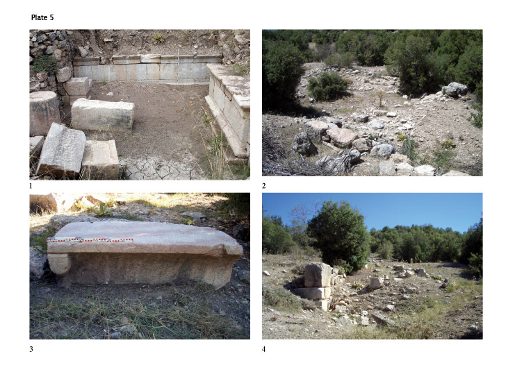
To the east of the terrace that contains the agora is a small rise topped by a flat open space that was dominated by various large buildings (pl. 5, 2). The plan of a few of them is discernible, though the preservation of the remains in this area is generally poor. The buildings consist largely of reused ancient blocks, often set in mortar. The large size of the complexes of rooms supports the suggestion that the area was reserved for public buildings. Though it has not been possible to assign dates to the individual complexes, the methods of construction point to a Byzantine date, probably following a development of this district in the Hellenistic or, at the latest, in the Roman Imperial period. Extensive use of the area in all three of these periods is attested by large numbers of pottery sherds. On the slopes of the small rise are preserved some remains of small-scale residential houses.
Domestic areas
Remains relevant to the residential development of Boubon consist mostly of small rooms, usually sharing walls. These structures are situated on elongated terraces that surround the western, southern, and eastern slopes of the Dikmen Tepe. The absence of more differentiated buildings, which is remarkable, is probably the result of topographic conditions. Most of the rooms have either been substantially destroyed by illegal excavators or are almost entirely buried. An irregular rubble masonry, often bound in mortar, is the typical construction, and chronological distinctions are not currently possible. The pottery sherds found throughout the area date from the Hellenistic period to late antiquity. The absence of cisterns is worth mentioning and can probably be referred to the deep earth overlying the remains. Ceramic pipes belonging to a water channel were discovered both in Boubon and its surroundings, but it has not been possible to determine at what point the channel reached the city nor how the water was subsequently distributed.
Some honorific monuments
In the lower area of the southern slope were erected several rectangular bases with honorific inscriptions as well as some stone benches with small profiled feet at their corners (pl. 5, 3). Five of these bases are inscribed, some of them containing decrees for deceased youths (see Kokkinia 2007). The monuments were situated beside a wall that apparently belongs to a U-shaped terrace construction, its southern front built of large hammer-faced ashlars. The eastern wall of this structure was more poorly built of roughly polygonal blocks (pl. 5, 4). The precise connection of this wall to the bases and benches is unclear. The benches, of various forms, together with the bases, could have belonged to one or more exedrae.